Featured Projects
Jiinue Growth Program MIS
Spearheaded the adoption of a PostgreSQL-based Management Information System (JMIS), developing visualizations to support decision-making and maintaining the overall data management. Led migration of 300,000+ records from disparate Excel files, streamlining M&E reporting for 7+ partner organizations while ensuring data integrity and timely donor compliance.
 Image Source: J. Owino
Catchment and Land Use Analysis
the spatial distribution of three major hydrological systems—the Lokok, Lokere, and Awoja Catchments—and their respective sub-catchments. It overlays this hydrological framework with current Land Use data, revealing distinct regional characteristics: Northern Catchments (Lokok/Lokere): Dominated by Trees, Shrubs, and Grassland, indicating semi-arid, mountainous, or grazing areas, which are critical for headwater protection. Southern Catchment (Awoja): Characterized by extensive Cropland and vast, connected Wetlands, signifying intensive agriculture and large floodplain ecosystems. The analysis is crucial for managing water resources, mitigating flood risks, and addressing the impact of agricultural runoff on the region's vital wetland systems that drain toward Lake Kyoga..
 Image Source: J. Owino
Multi-Criteria Suitability Analysis
Conducted a Weighted Overlay Analysis (MCE) for intersection of child-care, poverty and climate effect in Madagascar, focusing on Atsimo-Andrefana, Androy, and Anosy regions. The analysis revealed areas of very high suitability (red/orange) in Atsimo-Andrefana and Androy, while Anosy presented a mixed profile, providing crucial spatial intelligence for targeted interventions.
 Image Source: J. Owino
Urban Development & Digital Mapping Consultancy
Led large-scale urban development and digital mapping initiatives across seven Kenyan counties (Meru, Samburu, Siaya, Kisumu, Machakos, Nyamira, Makueni). The core focus was preparing Integrated Strategic Urban Development Plans (ISUDPs) and Local Physical Development Plans (LPDPs) for sustainable planning and informal settlement upgrading.
conducted reconnaissance, base map preparation, and socio-economic data analysis, using GIS and spatial modeling to design key sectoral improvement plans (transport, housing, environment). This provided county governments with robust, data-driven planning tools to enhance urban management and climate-resilient strategies.
 Image Source: J. Owino
Lismore City Flood Extent Analysis
Conducted a critical flood extent analysis of the devastating 2022 Lismore floods. The project leveraged Sentinel-1 Synthetic Aperture Radar (SAR) imagery and high-resolution Digital Elevation Model (DEM)data, executed within the Google Earth Engine (GEE) cloud computing platform.
The primary objective was to accurately map inundated areas, which facilitated the identification of affected urban, residential, and agricultural zones. Final flood extent maps and geospatial data were processed and visualized in QGIS to support immediate post-disaster assessment, long-term resilience planning, and future flood mitigation strategies for Lismore City.
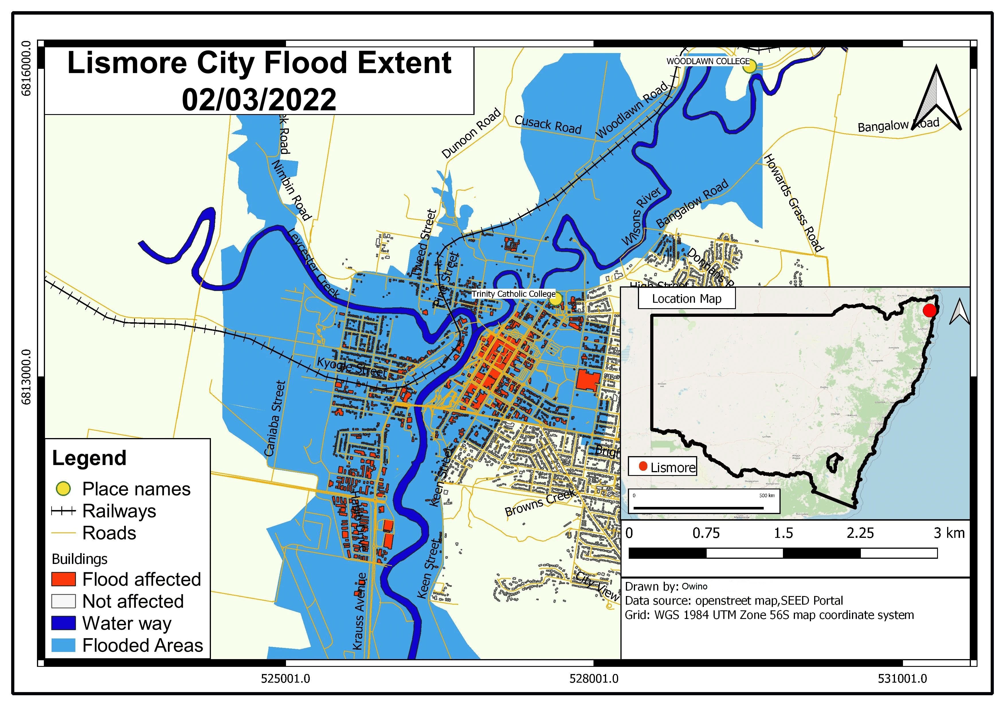 Image Source: J. Owino